FLAMING GORGE N. P., (UTAH/WYOMING) May 29 to June 1)
On Thursday, the 29, we drove to Vernal, UT. We decided to spend the night in a Motel after driving about 350 miles today on U.S. 6 and 191. We drove through some very diverse countryside - high desert, farmland, range land, and a number of mountains. It was all interesting and the countryside very beautiful. It was difficult to take a nap as you might miss some interesting geological formation. Once we made it to Vernal we ran a couple of errands for dinner, gas, and a new case for George’s weatherman knife.
Friday morning we enjoyed a continental breakfast in the Super 8 Motel before heading North to The Flaming Gorge National Recreation Area. We set up camp at Red Canyon in the Rim Trail Campground. It was hardly being used, and we had a tent only site which when you looked out the tent in the morning you were seeing sunrise over the Gorge. It was a nice 1.5 mile hike to the Visitor Center where we made a connection with the Volunteers there and learned about the area.
 |
| Western Larkspur |
 |
| Broadleaf Beardtongue |
 |
| Spearleaf Stonecrop |
 |
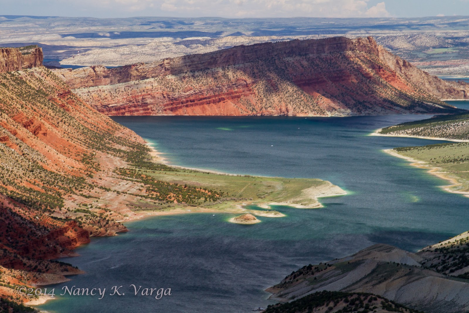
| Red Canyon Rim View |
 |
| Flaming Gorge Reservoir with Storm Clouds and Rain |
As we left we were greeted by a small herd of 7 Rocky Mountain bighorn sheep. It was a little work to take pictures of them without the flagpole or other signs in the background. They were not nervous about the people activity if you moved slowly and quietly.
While we were away from our camp there was a small rain shower that left a small puddle on the table and on one of our camp boxes. We had only felt a few drops. The sky was quite stormy looking until after sunset which did not occur until about 2040. Enjoyed some quiet time reading before going to bed.
Saturday, 31 May, we were up just as the sun rose. I quickly grabbed my camera and headed for the Canyon rim to capture the light. Got a few good shots before the sun went behind a cloud for a short time. When I returned to camp George pointed out a couple of marmots near the rim. We both got some good photos of them.
 |
| Morning Light on Canyon Wall |
 |
| Western Blue Flax |
 |
| Tapertip Hawksbeard? |
 |
| A Member of the Sunflower Family |
 |
| Gooseberryleaf Globemallow |
 |
| Marmot |
After breakfast we drove the Sheep Canyon Geology Loop. It was fascinating with formations rising diagonally, and vertically. There were about ten different rock layers on this short 25 mile loop. I would say one was an anticline formation. The rock history is over 6 million years old.
From a distance we could see the walls of the Gorge carved by the Green River. When
you see this you will fully understand why John Wesley Powell named the gorge as he did: "Flaming Gorge".
It was quite windy this afternoon so we actually sat in our tent to read and relax. Later in the afternoon we again hiked to the Visitor Center. This time I talked with one of the Forest Service staff about points of interest for our drive tomorrow, as well about some of the flora in the area. While we were there we were alerted to the fact that the herd of bighorn sheep was ascending from down in the Canyon. You could see them coming up from the windows of the V.C. I took a number of photos of them coming up the slope. We then went outside and watched them on the rim scurry off. It was really neat seeing them scamper up the slope.
 |
| Climbing out of the Canyon |
As we walked back to camp it was still windy and we could see a wall of rain approaching from the West. We did not think that we would make it back to camp dry, but we did!! As a matter of fact the rain squall never reached our area. There was no sunset so I set to making our dinner of chili and tortillas and cheese with some chopped tomato, an easy meal for me and for the clean-up. It was not long before it was time to go to bed as sunset is about 2040. We stayed up long enough to watch the stars appear, and identify some of our favorite constellations and the visible planets: Jupiter, Mars, Saturn, Scorpius, Gemini, the Big Dipper, etc.
Sunday, June 1: Got up once again for early light.
Then it was time to pack up our camp and head for Wyoming and wild horses. We are getting better with breaking camp with more practice and working out how to store the tent and poles, etc. We have also been able to add a bit more to the car top carrier which frees up a bit more space in the car. I may do a little more consolidation and purging of unused gear when I get to Ashton and before we head for Glacier N.P. and points North.
On the way we stopped at the Dam, and then crossed the bridge to the East side of the reservoir. While at the V.C. I picked up Rachel Carson’s book,
Silent Spring, which in all these years I have never read!! Will probably start reading in as we leave Ashton. I had hoped to get to see the “Flaming Gorge” formation from the Antelope boat dock area but we learned that the road had been converted to dirt and was in very poor condition, so we passed on that. There was also supposed to be an Antelope Valley Overlook which somehow we missed. It may have been on a Forest Service Road which we did not identify. We did get to Firehole Canyon which was entirely different in geology from what we had been seeing in the sagebrush prairie that we had been driving through, and the area west of the Dam where we had been camping at Red Canyon which was high forest area full of ponderosa pine forest.
 |
| Add caption |
We did get to Firehole Canyon which was entirely different in geology
from what we had been seeing in the sagebrush prairie that we had been
driving through, and the area west of the Dam where we had been camping
at Red Canyon which was high forest area full of ponderosa pine forest.
 |
| View from Boat Launch at Firehole Canyon |


No comments:
Post a Comment